Thursday, August 29, 2013

Into the Pacific Northwest

Leaving Yellowstone, we traveled back north through Montana and across Idaho on US-12, a long and winding path through miles and miles of tall, foggy, green Northwest pine forest. I really enjoyed this drive - it was not crowded and wound along a picturesque rocky stream the entire way. We camped once along this route, and headed into Washington to the city of Ellensburg.

Here, the forests and moisture were gone - the flat, irrigated land of Washington was home to some of the most interesting farms I've seen, including hay, apple, potato, grape, and onion farms.


We camped two nights along the Yakima River with the sole purpose of taking downtime and planning. The last month of the trip would be busy with much ground to cover, so we planned out our days, drives, hikes, and contacts on Tuesday and Wednesday. It was generally successful: except for about a week in Utah to split between 5 major national parks, we know our stops and path for the remainder of the trip. So much planning went in before leaving that it's almost strange to be near the end of planning things out. Time, weather, and the van willing, we have a goal: travel south through California, explore the Southwest, then return to Blacksburg for the weekend of October 5 and head home the Monday after - 14 weeks to the day from when we left.

We drove to Redmond just outside Seattle on Wednesday to change gears completely: here, we met up with Drew and Maddie again and prepared to spend the weekend camping at The Gorge Amphitheater to see a 3-day Dave Matthews concert. We had had tickets before we even left Virginia, so the excitement and anticipation was high - and we had finally made it!

Monday, August 26, 2013

Yellowstone National Park: The Canyon

The second half of our Yellowstone stay was spent exploring the canyon area. Here, the Yellowstone River has cut out a large ravine, and it is unique because of the colors of the rock. The geothermal bacteria present in the area leaches out different minerals from underground, causing the rock to turn shades of pink, orange, and yellow and making photographs of the canyon look almost unreal.


We hiked around the area for a while, but the highlight was Uncle Tom's trail. The trail is really more of a 300-some step metal staircase which goes down the canyon wall near the base of the Lower Falls.

Uncle Tom's "trail"

The close-up falls view

Just upriver from here, there is a smaller set of falls called the Upper Falls, which are a mere 100 feet tall compared to the Lower Falls 300-foot drop.

Looking down the cold, thundering Yellowstone River

After spending Saturday around the canyon, we said goodbye on Sunday morning: we would not see Drew until the end of the week, where we would meet up again outside of Seattle. The company was great, and it was great to see one of the country's top national parks together!


Saturday, August 24, 2013

Yellowstone National Park: The Geysers

My apologies for the delay in updates - they've been written, organized, and saved in various places, but I'm taking the time today to get them all up on here. 

The drive to Yellowstone - starting on Wednesday, August 21 - was good: it was pretty, bordered on both sides by parts of the Rockies and spotted with lakes. And like much of Montana, we saw few other travelers the entire time. We stopped in Helena, MT for one night and treated ourselves to dinner out after the long stretch of camping. It hit how far away from home we were when Jenna ordered a beer with dinner: our waiter, in his mid-forties, remarked that he had never seen a Virginia license before and that it "looked neat."

We met Drew and Maddie in the park, ending a two week stretch void of familiar faces while traveling through the barren Midwest. I was certainly glad to see a fresh, well-known face - especially from such an old friend. We set up camp on Thursday and did a small hike around Yellowstone Lake, and on Friday morning, we ventured out onto the lake in a rented rowboat together. We found out that rowboats, which require rowing in pairs, are more a test of strength and communication than a relaxing morning on the lake - though we definitely had a good time with it.

We explored Yellowstone's signature geothermal fields. I knew little about these going in - only that Old Faithful was here - but they were spectacular, and it was the highlight of the park for me. Hot magma flows close under the ground here, causing the groundwater to become heated and pressurized to the ponit of creating geysers and springs on the surface. This water deposits dissolved rock, harbors nearly-alien rainbow-colored bacteria, and creates a landscape that you might envision on Venus.


The springs and geysers are more than pictures can convey. The sounds are wild; some geysers dry up and become steam vents that whistle and howl so loud it sounds like a tornado. The smell is distinct too - reactions with acid, mud, and bacteria produce produce a strong, distinct sulfur odor that covers the geothermal fields. The water is generally about 150 F even on the surface, so there are always huge clouds of steam rolling off the top of the springs.

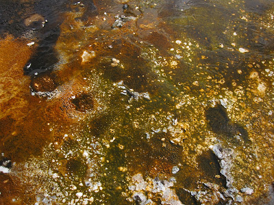
Anaerobic, heat-loving bacteria thrives in the mineral water

A huge hot spring: we could see down to at least 40 or 50 feet

A "mud pot" where the steam and heat bubbles up through mud pits

We watched the famous Old Faithful go off as well, which was obviously a popular attraction in the park. Interestingly, the geyser was named so because it went off every hour about 100 years ago. Now, it erupts every 90 minutes, and as the underground conditions constantly change, it could slowly die out - not really so old or faithful after all.

Old Faithful

And the crowd watching


Wednesday, August 21, 2013

Glacier National Park

We spent 2 or 3 days to drive up Montana to Glacier National Park. The drive was pretty monotonous: lots of cow fields, lots of cows, and a sparse few cowboys here and there to take care of them. The park borders Canada (so it was a long way up and across Montana), but it was worth it for the hands-down highlight of the trip so far.

The mountains are majestic and grand, accented by the water-falling streams that run down the sides. Glaciers are scattered throughout the peaks; so are prairie-like meadows bursting with wildflowers. The highlight is driving on Going-to-the-Sun Road through the park; this road is described (quite accurately) as one of the most magnificent highways on the planet.

The Rocky Mountains

A typical glacial lake

Heavens Peak, carved in layered, curvy shapes by glaciers

McDonald Falls

We went on a few hikes during our two days there to explore the area, including hiking to Avalanche Lake, bordered by spectacular peaks and waterfalls.


The waterfalls and streams, often bordered by rock or meadows, are another beautiful part of the park.


We also hiked up to see the Sperry Chalet. This cabin-like lodge has 17 rooms, a separate dining room, no heat or electricity, and is only accessible by hiking at least 6 miles. All supplies and food are brought up the hiking trails by horse.

The view from the Chalet


The Chalet dining room

The entire park is incredible; it was equally interesting to learn how and why it formed the way it did due to glacial action. I’m especially glad we trekked up to Glacier on this trip for another reason – the changing climate is predicted to melt away all of the park’s glaciers permanently by 2020. The effect on the landscape, wildlife, and ultimately the park is largely an unknown. So, it was a good time to visit, and quite an inspiration for gearing up to seeing the rest of the Rockies - including our next stop at Yellowstone National Park!

The Black Hills and Badlands

The first day in the Black Hills, we drove the Peter Norbeck Scenic Drive, a route that winds through much of the region and the views, landscapes, and wildlife. The route was a very slow, windy mountain road; some one-lane tunnels were as narrow as 8 ft.


 An obligatory stop on this drive was Mt. Rushmore. It was neat to see, but not breathtaking. (My opinion may have been swayed by the fact that our federal land pass – which waives entrance fees to any federal park or lands – did not cover the $11 parking fee.) I enjoyed walking through the sculptor’s studio the most, which contained several mockups and information on the monument’s design. The actual monument is smaller than you might imagine, and the entire place strongly resembles an amusement park.

Me (and everyone else) at the monument

The original Mt. Rushmore design

The wildlife was most active through the southern prairies of Custer State Park, which we hit on the way back down from Mt. Rushmore. Bison wandered aimlessly, including on the roads in several places. I spotted antelope, bighorn sheep, prairie dogs, and even donkeys.

Bison in the road!


Huge roadway bison guards
 
Near the end of the drive, we hiked up a fire tower to get another view of the region, and we went on a walk through the prairie that ended when we encountered a rather territorial coyote. It was a long day, made longer by a severe thunderstorm and tornado warning that evening that prompted an evacuation of the campground to the visitor’s center. Fortunately, there was only some rain and marble-sized hail – no wind or damage to anything.

The top of the Rankin fire tower

The next day we hiked up Harney’s Peak, the country's highest peak east of the Rockies. The views were spectacular, and the hike wound around several different kinds of forests and some of the interesting rock formations we had spotted the day before.


The rocky Black Hills


Harney's Peak lookout tower

Harney’s Peak was just a stop in the morning; afterwards we drove east out to Badlands National Park. This area is really intriguing – it seems much more Mars-like than terrestrial. We drove through the park and hiked up one of the massive dirt structures.


That night, we camped at Sage Creek, a campground that consists of nothing more than a road and a few tables in the middle of the park’s prairie.


Afterwards, we were back on the road - this time to Glacier National Park!

Through the Midwest

After leaving Michigan, we traveled across northern Wisconsin to Minneapolis, Minnesota, where we spent one night with another friend of Jenna’s through Barton Malow. The drive was a continuation of forest and farmland; much of it was actually the classic dairy-barn-with-dome-topped silo landscape that I had imagined it to be.

In Minneapolis, we met Jenna’s friend Joe and some of his friends he knew through his summer internship. I enjoyed seeing the city because I have read that it is one of the cleanest in the country and has a highly-regarded park/greenspace system. It was clean and planned well; the layout reminded me somewhat of Richmond – a lot of brick buildings and a river that cuts right by the downtown area. We went to a street festival with live music downtown, and we also took a quick trip up to a rooftop bar to get some neat views of the city. It was good to have a place to stay, but the city’s late nights and expenses were taxing compared to our standard trip routine, so I was glad to then head back out into wide open spaces. We did stop the next day on the way out at the Blue Door Pub where I got my first (and a very good) Juicy Lucy.

We spent 2 days driving to get through Iowa and Nebraska into South Dakota, where we stayed two nights at Wind Cave National Park. The drive finally broke us out of the forest and into corn country, which transitioned into miles and miles of rolling prairie in western Nebraska.

From farm country...

...to prairie country

Wind Cave National Park is in the Black Hills of South Dakota, and area that was recommended by a surprising number of people. It comes almost out of nowhere, generally with the appearance of a much larger version of the Blue Ridge Mountains. However, the entire region is really diverse – these hills hold some staggering rock formations in the middle, and change quickly to open prairie and back. This mix of landscapes is what really made it interesting and pretty.

Friday, August 9, 2013

Michigan

After a rocky trip east, we arrived on Friday in Ann Arbor to stay with Jenna's friend Sheila. Sheila and the roommates were busy much of the weekend except for some time spent together on Friday and Saturday nights, so we were left to explore mostly on our own. We caught up on a lot of writing, reading, and errands, as well as ate at some very good Ann Arbor restaurants including the Jolly Pumpkin, the Prickly Pear, and Stucchi's Ice Cream. We also walked around part of the University of Michigan's campus; it was interesting to see and, like seeing Ohio State, really put Virginia Tech in perspective nationally.

The Bell Tower at U of M

After leaving Ann Arbor, we camped two nights outside of Sleeping Bear National Lakeshore on the Lake Michigan Coast. I was slightly unsure of what would actually be there; I had pictured the Michigan shores as cold and bland from being so far north. However, I was amazed - our first day took us on the famous "Dune Climb" and hike to the Lake Michigan shore, which is astounding. The hike itself was about 1.5 miles through loose sand over large dunes, so it was a taxing hike. The lake water is clear baby blue; the sand is orange-y, clean, and scattered with light, rounded stones. Even for a cloudy day, it was a very pretty sight to see.


Looking back away from Lake Michigan to Glen Lake

The next day, we hiked the Alligator Hill trail before leaving - the lookout at the top was equally impressive, and the water looked like something I would imagine out of Hawaii. After visiting both Maine and Michigan, it's clear that Northern summers are really beautiful - despite the cold weather than dominates the other 8 months of the year.

Looking across Lake Michigan to the Manitou Islands

We camped once near Mackinaw City en route across the Mackinac Bridge and onto the Upper Peninsula. We stayed two nights in Hiawatha National Forest - it was nothing special, but it allowed us a couple slow days to catch our breath. After staying with people pretty constantly, we took the time to get out and be active as well as plan our next steps: we settled on the path and places that will take us through the upper Midwest to South Dakota and the Black Hills for a few days in the coming week!

One of our 'deluxe' dinners!