Friday, October 11, 2013

The End: A Final Wrap-Up

Now that I've finished traveling, I'm at home, contacting and interviewing with different civil firms throughout eastern Virginia. I want to say thanks for reading to the end, and I hope it was an adventure to hear about my own adventure. It was fun for me to step outside my comfort zone and chronicle the trip like this.

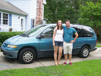
Before...
...and after!

I compiled some facts about the trip that I found interesting:

Total days: 99
Total miles: 17,700
States visited: 48
National Forests we camped in: 11
National Parks we camped in or visited: 16
State parks we camped in: 4
Total number of nights we camped: 51
Gas stations visited: 56
Number of friends or family we stayed with: 17

There are so many odd or strange things to count; I could go on and on.

Surprisingly, I ended the trip under budget - including fixing the car troubles we ran into. We budgeted the trip to cost about $4,600 for each of us, and it ended up costing me just under $4,000. The largest cost was fuel; we each spent $1,400 on gas and used about 800 gallons of gas total to travel the country. The federal land pass saved us hundreds of dollars and was a great investment for a trip like this. We kept things cost-efficient because of the style of the trip: we camped a lot and bought food from the grocery store, but we still had some great foodie, touristy, and fun experiences when we stayed with others. Considering what I got to see and do, I believe the trip was an incredible bargain.

The path of the trip - my map finally complete!

This is the end of my posts about the trip these past 3 months. Thanks, and I hope it was fun - it sure was for me!

Tuesday, October 8, 2013

Back to Virginia

Wednesday night we arrived in Auburn, AL to stay two nights with David. He is a grad student in English at Auburn University, and he had met us previously to join our weekend in Nashville. The drive didn't seem too bad, though it was about 12 hours. Driving through the Alabama countryside was the first time it hit me: there weren't anymore deserts or mountains or red cliffs. There was green grass, trees, and farms - this looked like home!

On Thursday, we organized and cleaned some, taking a day to catch up before a hectic weekend in Blacksburg. We also explored Auburn's campus. Here, the Southern influence was very strong: the campus had traditional brick architecture and centered around the massive football stadium, and the majority of the undergrad students were involved in a fraternity or sorority.


Friday was the critical day that we had been focused on for weeks: we drove back to Virginia. Looking back, arriving at Virginia Tech and arriving at home in Poquoson were great feelings, but they were not overwhelmingly emotional. What was overwhelmingly emotional was crossing into Virginia: this was the moment at which I finally felt home. We stopped at the welcome sign to take our last - our 48th - state picture. My eyes (slightly watery) felt glued to this huge white sign and everything that it meant: the trip was incredible, but it was hard, and this huge white sign meant that I was back, back to the people, places, and opportunities that awaited at the end of the journey.

Home!

We saw old friends and old faces in Blacksburg, and we went to the VT vs. North Carolina football game on Saturday with David. It felt good to be so close to home.

After the weekend, I drove home on Monday stopping to drop Jenna off along the way, ending our journey. We finished what we started out to do, and now we're home! I'll post more about that in one last blog post during the next few days - a summary of interesting facts and a look back on the trip.

Thursday, October 3, 2013

Across Texas

Leaving New Mexico on Monday, we headed into Texas, but not before swinging briefly up to Kansas and Oklahoma for state sign pictures there. In my opinion, Texas is one of the biggest "can't see it all" casualties on the trip: we drove through the northern part of the state, stopping for only two nights. The size of Texas is a challenge because of the time and money involved to cross the state, not to mention we had no connections south or west of Dallas. So, though it's a shame to me, we bypassed much of the state. I'll have to visit in the future.

Our first night, we stopped in a small hotel in Childress, TX. The experience in this small town was exactly what I envisioned of Texas: a lot of cowboy hats and boots, very big trucks, and thick accents. I enjoyed people-watching during dinner at a small restaurant. My experience from traveling the states is that Texas and California are two states that have really developed a culture of their own with interesting differences from anywhere else, and I really like observing these differences.

After two long days on the road split by our night in Childress, we arrived to Dallas to meet Matt, an MV alumnus who played in the tuba section with me for 3 years and moved to Texas to work at Texas Instruments. What I noticed on the drive into Dallas was the sprawl: the land is so flat and abundant near Dallas that things just kept moving outwards. A current map of Dallas shows the numerous encircling beltways and huge metropolitan area that has developed.

Downtown Dallas on the drive in

On Tuesday night, we walked around the uptown Dallas area near where he lived. Like most cities, the trendy and hip uptown area was full of younger professionals, wealth, garden-style condos, and restaurants that all looked worthy of a visit. We ate at Urban Taco, an incredibly delicious modern take on Mexican food. Afterwards, we walked around and headed up the parking deck Matt's apartment. While his apartment had no view at all, the top of the parking deck was 6 stories up and overlooked the entire nighttime skyline of Dallas.

The next morning, we drove out of Dallas for a long-haul day across the South to Auburn University to meet up again with my good friend David. As we left Dallas, we drove through the High Five - one of the country's tallest, biggest, and most complex highway interchanges. It is so named because there are five planes of ramps and highways stacked on top of one another. I thought this was neat, though most people wouldn't think twice about it.

A bad picture of driving through the High Five

The long drive after flying through the High Five would leave us at Auburn and with only two days left before our exciting return to Virginia!

Tuesday, October 1, 2013

Great Sand Dunes National Park and Taos, NM

On Saturday, we hit the road east for a long drive back across part of the Rockies on Highway 160. It was pretty and green, and the snow-capped mountains looked tall in the distance.

Colorado driving

Eventually we crossed the Rockies (where they were plowing the snow off the top of the passes already) and drove into the San Luis Valley in eastern Colorado. Here, we planned to visit and camp one night at the Great Sand Dunes National Park.

We arrived to find that it was National Public Lands Day - which means free admission to national parks. (Ironically, 3 days later, every national park in the country would shut down...)


In this valley in Colorado, wind patterns have been depositing sediment for 500,000 years in order to blow up and over the Rockies. This has left an enormous dune field, right next to the Rockies and bordered by otherwise by two streams. It is very strange at first, but it's very cool.

Looking to the valley past the beginning of the dunes

We hiked to the top of "High Dune," one of the first major peaks in the dune field. The dunes are open to everyone, and there are no marked trails; you simply make your own way to the top.

Looking up to the top - over a 1 mile hike

Looking down from the top


After leaving the sand dunes on Sunday, we drove south through New Mexico and stopped by the oldest still-inhabited village in the United States: the Taos Pueblo. Here we took a tour of the old village, learning both about the adobe architecture of the 1300 year-old buildings there and some about the pueblo Indian culture of the tribe. The architecture and buildings were neat; small markets and shops were in the first floors selling things like Indian-made shoes, jewelry, and adobe oven-baked bread. The culture was closed and guarded - I have no pictures here because cameras weren't allowed in due to the tribe's ongoing preparations for a harvest festival. Their religious ceremonies and practices are secret and kept within themselves, strangely opposite of the outward-spreading goals of larger religions.

Late on Sunday afternoon we left Taos, NM and headed east. After crossing the last part of the Rockies, we were back on the plains again and camped on the east side of the state: next stop, Texas!

Sunday, September 29, 2013

Canyonlands National Park

On one of our three days in Moab, we drove out to Canyonlands National Park. The park has two main areas; we visited the Island in the Sky district while staying in Moab. This area is a large mesa top that overlooks both the Colorado and Green Rivers on either side and the stunning canyons the rivers have cut. For a lesser-known national park, I was surprised at how scenic and enjoyable it was!


One hike we did was to Upheaval Dome, a 2-mile diameter crater in the park. Geologists say they can't figure out why it's there. It's pretty strange, filled with piles of mystery grey-colored sediments but surrounded by red sandstone.


We left Moab on Friday after our windy, sandy three-day stay. We didn't get out before the weather gave one more blow: light rain our last night there meant that the tent and its contents were not only sandy, but wet. It was a mess, but fortunately the inside of the tent (and the contents) remained mostly dry. We repacked the car and headed out to the other half of Canyonlands NP: The Needles district. This part of the park is remote, less visited, and known for a range of rock spires that looks like a field of needles.

Our first task was to find a campsite, which proved to be one of the strangest encounters we've yet had on the trip. The campground in the park was full, so we went to the private campground just outside the park. Here, we looked around at the spots to pick a sunny one to dry out the tent and equipment: this was our cardinal sin. When we headed in the store to register with a spot in mind, the woman owner instantly jumped us, asking "if we could read" and telling us that we were supposed to register before looking around. Despite my explanation, she could have cared less and said she had "no interest in people like you" and that we were "welcome to camp up the road somewhere else."

We left (sort of stunned) and drove a few miles back down the one road to the park to explore the BLM lands for camping spots. However, all of the roads were impassable for the van, especially after the recent rains in the area. There were no other camping options, and we had no choice but to make our visit to the park quick and just keep heading down the road afterwards. We checked out the visitors center, drove through the park, and walked two short hikes to a canyon and a strange pothole-covered rock.

Looking across Canyonlands

We left and found a National Forest campground just outside of Monticello, UT. We arrived late in the afternoon but still in time to unpack the tent and tarps with the hope that they would dry out. Because of their condition, we would have to sleep cramped in the car. Another reason to sleep in the car was the record lows forecast for that night of around 30 degrees. Despite our positive hopes leaving Moab that morning, we found ourselves once again sleeping in the car to avoid the cold, windy weather.

Our poor tent before cleaning and drying out

Cooking in the car for the fourth (or something?) day

We woke up on Saturday morning to a temperature of 27 degrees and frost on the inside of the car windows. We packed up the tent as quickly as possible. It was much cleaner, though it was covered in frost that would inevitably melt in the car. Even though the night had been cold and planned last-minute, we made it, and we set out for Colorado around 7:30 AM. Only two nights of camping were left while heading southeast and down in elevation to our sprint east and home, which left us with hope that things would only go uphill.

After so long on the road and the recent tough weather, we're in New Mexico now with a week left. I'm hopeful and excited to finish so soon: surely we can survive whatever is left!
Friday, September 27, 2013

Arches National Park

We arrived in Moab, UT in the early afternoon. After setting up camp just outside the town, we went into Arches National Park to drive around.

Arches - like the rest of Utah - is formed out of red sandstone, which in this particular location has eroded into all sorts of fantastic and impossible-looking shapes, obviously including arches. The landscape is generally flat, bordered by the towering Rockies to the east, with strange sandstone fins and shapes protruding from the ground. We saw many of the park's named and famous formations that day driving around, most of which are very matter-of-factly named.

The landscape of Arches NP


Balanced Rock

Double Arch

The Windows

We took another full day to do two long hikes in the park: the first through the Devil's Garden, and the second to Delicate Arch. The Devil's Garden was a fun and challenging trail, half of which looped through the sandstone fins and required some climbing and a lot of trust in your feet. This trail winds past several arches and other formations, including the world's longest arch, Landscape Arch.

The Devil's Garden trail

Double O Arch

Landscape Arch - 100 yards across

It was clouding up by the time we finished and headed to Delicate Arch. This arch is the iconic image of Utah and seemingly the entire West, so I was excited to visit it. It is big - probably 50 feet tall. I think it's most intriguing because it seems to just stand on its own, unconnected from any surrounding fins or rock, unlike many of the park's other arches.

The world's most famous arch!

Me under the arch for scale

Our stay in Moab - which included one more day to explore part of Canyonlands National Park - was not as smooth as our visits to the parks. We happened to arrive as a weather system was pushing strong winds around 50 mph through the area during the days we were there. The tent was no match for the weather, so we gutted the extra seat and stuff from the van, put it in the tent, and collapsed it and weighed it down. This gave us the entire back of the van as wind-free living space; we had to cook, eat and sleep in the van for the three days and nights in Moab.

Our site and the tent in collasped-storage mode...

The wind itself was not our only enemy: the desert sand that it blew around was just as bad. Only after our pillows, mats, and sleeping bags got covered in sand during a particularly strong gust did we learn to always keep the car shut. And it made all the hiking more difficult: the sand stung my skin and ended up in my ears, eyes, and mouth. It was a particularly tough place to camp, but our spirits were propped up by the quickly-approaching end to the camping portion of our adventure and the return to sleeping under a roof!

Wednesday, September 25, 2013

Bryce Canyon National Park

Less than 100 miles from Zion, our next stop was Bryce Canyon National Park. It's more of a long ridge that is eroding spectacularly than a true canyon. We spent an afternoon driving along the ridge, stopping to do several short hikes to viewpoints, before camping there that night.

Just as Zion is the beginnings of a Grand Canyon, Bryce is the beginnings of another Zion. Here, the gulleys and carvings that water and ice have left are in their smallest state, just forming. Erosion and weathering have created this panoramic maze of hoodoos - small, odd-shaped rock formations - that stretches out for miles with the same diverse color palette as Zion, still slowly eroding away today.


The weather was cold and breezy while we were there on Sunday afternoon, and the clouds and surrounding rain showers made for some great pictures of Utah's high plateaus and the hoodoos.


The hoodoo structures and eroded rock are fascinating: I could (and did) spend hours taking in the patterns and shapes.


The cold day meant that the night would be even worse: we decided to settle for an uncomfortable night sleeping in the car rather than in the tent and severe cold. Sure enough, we woke up on Monday morning to frost on the van windows and a temperature of 32 F. 

On that morning, we hiked down under the rim for several miles through the hoodoos. It was neat to hike around and (literally) through them, yet the hike was tough due to the multiple ups and downs in the canyon. They are very large, most 30 or 60 feet tall. They are also surprisingly fragile - the sandstone will rub off and fall away as sand with just the touch of your fingers.

The scale of some small hoodoos...

...and some much larger ones.


Often the trails cut straight through the rock.

Our visit was great, but cold. Fortunately, we had a planned hotel stop on Monday night to rest warm and well. This hotel stop in Richfield, UT was the midpoint of our drive east across the state - on Tuesday, we arrived in Moab to start our journey through two of Utah's eastern national parks: Arches and Canyonlands.